Signal Hill, Hilltop Park, CA
Two words I love are "useful" and "free." When I think of things that are useful and free, Google Maps comes to mind. And yet, there are areas where Google maps aren't so useful. What if you simply want to map your transmitter's range for your next flight? In this hypothetical example, we'll look at Hilltop Park in Signal Hill, CA. What better place to illustrate your transmitter's signal than Signal Hill? If you visit it on the right day in Los Angeles, it's lovely. You can see all the way to Downtown Los Angeles and out to Long Beach. The strange thing about the park is that it's only 110m(365') above sea level. But, it's in the basin of Los Angele which is fairly flat, thus you can get a wonderful panoramic view. Of course, the first thought that comes to mind is not "This would be an excellent makeout spot" but instead "Hey I want to fly my plane from up here!" It's a bad idea for a number of reasons, aside from the legality of it the fact that it's densely populated once you leave the park and a crashed plane very easily could create property damage. But the point remains, what radio system could potentially get you to the waters of Long Beach?
I am going to bring up four popular receivers
Spektrum AS3X- 300m range?
FrSky XM+-1K range

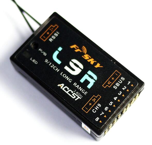
FrSky L9R->3K Range
TBSCrossfire-6K+ range

The FrSky is fairly well published. Spektrum says the AS3X is "Full Range" and doesn't really disclose hard numbers. Thus, I will trust it for the first 1000 feet. The TBS Crossfire runs in the 900mHz range and under the right conditions and right tools can go 30K if not more. 6K is perhaps an understatement, or maybe not? More about radio range later.
One incredible mapping overlay
Here's a link to the map I am about to share. In it, you'll see four circles.
AS3X
The first circle is the Spektrum receiver's range. 300 meters is around 1000 feet. The good news is that it will cover the entire area of the park. The bad news is water is nowhere in site. The AS3X is a Spektrum receiver with flight stabilization built-in. It's really more of a line-of-sight receiver than one built for FPV. I'm sure range is further than 1000 feet, but 5 times further? Unlikely. There is a Home Depot and Costco just below the park and chances are good that you can still see your plane after it goes out of range. That means that the receiver is fine for park flying but for long range FPV we have to look elsewhere.
 |
| AS3X Ramge |
 |
| XM+ |
FrSky XM+
The XM+ is an SBus receiver with just one set of pins. On that one set of pins it puts out 16 channels. It's tiny and very light. The advertised range is 1km though others have gone much further under certain conditions. Low to the ground in busy areas the range can be below 900 meters.
The small circle in the center is the Spektrum AS3X, the larger circle is the XM+. That's what five times the range looks like. Impressive but still nowhere near water. It's great for FPV where you're staying fairly close to where you're standing. 1km is a bit too far to see with most planes thus it's ideal for FPV. Still, we need more range if we're going to make it Long Beach.
FrSky L9R
It's time to pull out the big guns. The "LR" in "L9R" stands for "Long Range." The specs say that the L9R has a range that is greater than 3km. Cool, but, what is that? Since they came up with the number 3km that's what we'll use.
 |
| L9R |
TBS Crossfire
One does not merely buy an FrSky radio system. When you buy the Taranis you're investing in FPV. Still, if you want to go further there are more options. When you get into OpenTX and INAV what you're essentially doing is using a radio to have one computer negotiate with another computer. You will not be able to see your plane 1K out and you cannot trust that your video transmitter is going to work flawlessly. You need a failsafe, which is a computer that will fly your plane back to you should you lose signal in either your radio receiver or video transmitter. And yet, if you want more range you'll have to move on to newer technology.
 |
| TBS Crossfire |
Radio Range-Having a healthy sense of scepticism
We'll be flying at a dry lake in the coming months. There is nothing around. No hills, no trees, no buildings, no radio interference to speak of. Just flat, wide open land. The radio range will be off the charts because there isn't much to interfere with a radio signal. This map is the polar opposite. Trees, buildings, some small hills, and a solid ton of radio interference, even on 900mhz.
I'm certain that people are getting a solid 1K on the AS3X, while others have advised me that they get 3K from the XM+ and there is a video of the L9R going 14K while people are taking the TBS Crossfire out 30K+. If you can monitor RSSI values while flying it certainly helps.
Here's a video from the park in question. At one point you can see the Home Depot and Costco where he probably would have lost range with his drone.
A more practical application.
One of my buddies has a timeshare in Cab San Lucas. I've gone with him before and flew planes on the beach, it's a ton of fun. At the end of the harbour is Los Arcos, which is famous for its beauty. The question is, what radio can he use to make it to Los Arcos?
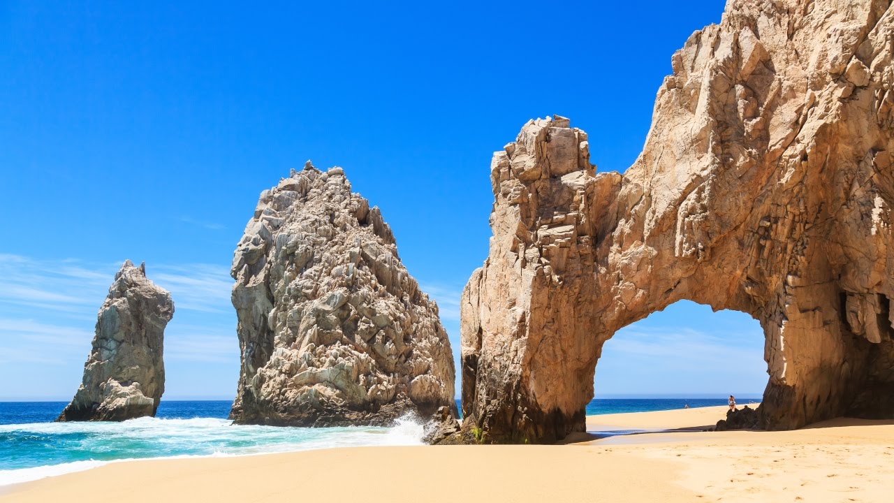 |
| Los Arcos, Cabos San Lucas Mexico |
 |
| Cabo San Lucas |
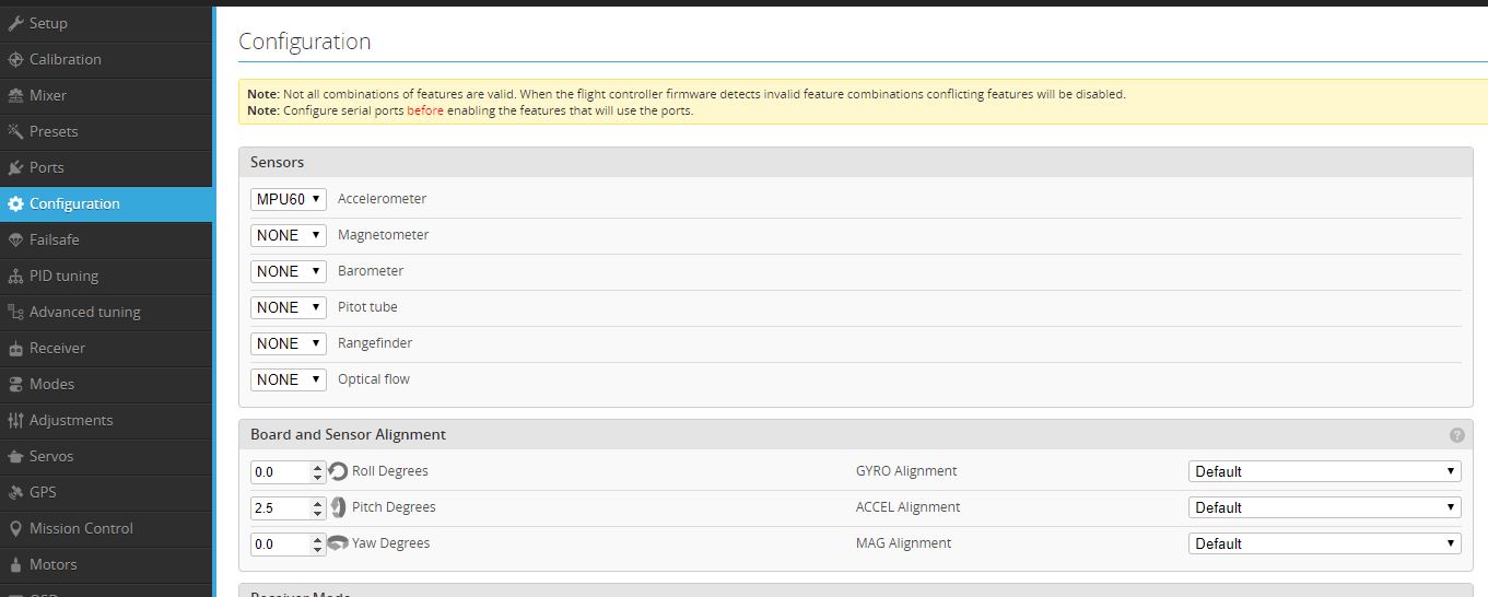
This is a 1K map and this is about as close as we can walk without having to get a cab ride to the other side of the Marina. This is a 1K radius which means that the circle is 2K Los Arcos is just outside the 1K radius, but not by much. Be sure to update your firmware to get RSSI readings. Be certain that your failsafe settings are legit because you may be using them.
The Golden Gate Bridge
 |
| Golden Gate Bridge, San Francisco, CA |
 |
| Golden Gate Bridge |
Drones are banned from flying on or near the Golden Gate Bridge. But let's imagine they were fine, or you have a wonderful lawyer on retainer. You can see that the L9R would cover the length of the bridge. The assumption would be that you would fly from the San Francisco side near the Golden Gate Bridge visitors center.
Lake Minnetonka
In the final example, I am imagining that I will make another trip to the city my wife is from, Minnetonka, MN. And I can talk someone to dropping me off on some desolate part of the lake. Before I even step foot on the ground I can figure out how far I can fly with an XM+ and where to turn around.
 |
| Lake Minnetonka |
Flight planning
You can use this tool (again, here's the link) so that you can quickly look at the range of locations you plan to fly. The tool works in metric and imperial units and you can save a link and keep it handy so that you can think of flight paths and landmarks to help you keep orientation. You can do "What if" scenarios and decide if you need to upgrade your receiver. As you can see from the examples you can view a map or satellite map.
Radio range
It's impossible to say exactly how far your radio will work. Instead of one factor there are as many as seven factors that have influence over your range. If you fly low to the ground in an area with a lot of radio traffic the range may be less than what's listed. If you're flying high in low radio traffic areas it may be considerably more range, perhaps twice to three times the suggested range. If you have a receiver with RSSI that will help alert you when your receiver reception is critical. Of course, all of this is based on the notion that your VTX will work further than your RX which is often not the case. With this tool, you can also start mapping the range where your VTX has fallout.
One huge benefit
It's easy to lose orientation easily when flying. With a GPS and INAV configured you'll always know where home is. But, I wouldn't rely only on that. Looking at the coverage circle on a map you can get a sense of where you're likely to fall out of range. You can look for landmarks in the area so that you know how far you can comfortably venture out to and where you should start turning back. You can even make a second circle that is 80% the size of the main circle,. You can visualize where you can make your turns. Look for recognizable landmarks from the air to help you know where to turn and how to get back.